Several Large Fires Burning on the Flathead Reservation
The Confederated Salish & Kootenai Tribal Division of Fire is battling several spreading wildfires in the Mission Valley area. Officials welcomes the arrival of more crews and equipment to join the fight. A Complex Incident Management Team will arrive tonight to take command of multiple fires. Extensive smoke has hampered efforts to gauge the current size of individual fires, but here is the latest estimates:
NIARADA FIRE
is estimated to be over 5,000 acres, burning 11 miles west of Elmo. Smokejumpers, a 20 person crew, air tankers, helicopters and heavy equipment have been are on scene.. The fire is burning in very steep and rugged terrain and spreading to the north and east, pushed by winds from the southwest..
MIDDLE RIDGE FIRE
BIG KNIFE FIRE
This fire near Arlee has grown to 3000 acres. The CSKT Fire Command says the fire is consuming thick standing and dead timber that has not seen fire in several decades. Measures are being taken to protect structures several miles from where the fire is burning in case a weather event pushes the fire west, into the lower elevations of the Jocko Valley. At this point, no structures are in immediate danger, and no evacuations have been ordered. Helicopters continue to drop retardant on the southwest flank to check the fire near Blodgett Creek.
Red Cross has opened evacuation shelters in Arlee at the Arlee Community Center, and one in Ronan, at the Ronan High School gym, due to fire activity on the Flathead reservation..
The Flathead Reservation fires are among a total of 77 active fires across the state, according to the DNRC's fire map, which gives few details on any of them. Most are less than 10 acres.
The Starling Incident was reported on Sunday in the Charles M Russell National Wildlife Refuge and quickly contained at 50 acres.
The Elm Coulee Fire has burned 438 acres in Richland County. It was discovered on July 24th, but it's not known how much of the perimeter has been contained.
Inciweb, the Interagency Fire service gives the following report on two major fires:
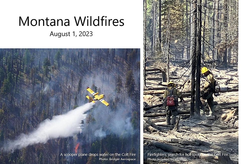
COLT FIRE
The fire remained active on Monday as temperatures increased and relative humidity levels dropped. Firefighters continued holding efforts on all sides of the fire. The overnight infrared flight mapped the fire at approximately 6,704 acres in size, an increase of 527 acres. Yesterday, on the southeast corner of the fire crews held the fire line and monitored for spot fires. Helicopters were used to cool hot spots as needed. Along the east side personnel mopped up and worked towards increasing containment along Forest Road 646 (Colt/Uhler Road). On the north side, crews and equipment took holding actions along the established fire control lines, monitored for spot fires, and continued to construct control lines. Along the west side crews worked upslope from Colt Lake taking the opportunity to work on direct fire line. With active fire on the southwest corner, aerial retardant drops were made to slow fire spread. Crews continued to work on direct handline construction working east to west and north of the West Fork of the Clearwater River. The Structure Protection Group patrolled Highway 83 and the structure protection zones as well as worked on structure assessments in the Lindbergh Lake area.
BOWLES CREEK FIRE
Last night, an infrared mapping flight showed an increase of 1,162 acres, and the fire now covers 2,876 acres on the Beaverhead-Deer Lodge and Bitterroot National Forests, east of Hamilton. Hand crews continue to lay hose and set up sprinklers along the northwest edge of the fire. Heavy equipment and masticators completed an indirect fuel break along aForest Road on the west edge of the fire. Minimal fire growth occurred on the southwest edge. On the east of the fire, heavy equipment continues work on fuel breaks and indirect fireline construction along Forest Road 5071 towards Forest Road 5070 and hand crews are strengthening fireline behind the equipment. High winds and lower relative humidity have allowed the fire to push at the east and south edges, and expand to the northeast across Bowles Creek. Helicopters as being used as needed to support operations on both ends of the fire area.
FLATHEAD NATIONAL FOREST
Flathead NF Public Affairs Officer Kira Powell reports that a dry lightning storm overnight between July 29 and July 30 caused an increase in fire starts on the Flathead National Forest. 17 fires have been reported since the lightning storm and firefighters are investigating smoke reports and conducting initial attack.
The largest new fires are the Kah Mountain and Bruce fires on the Spotted Bear Ranger District. These two are being combined with two smaller starts into the Tin Soldier Complex. Firefighting crews are responding with initial attack and a Type 3 Incident Management Team has been ordered to take command of the Tin Soldier Complex, estimated at 80-100 acres. Spotted Bear Ranger District has seven reported fires at this time. Alcove and Stadium Creek Fires are in the Bob Marshall Wilderness Complex. The 0.5-acre Elam Fire is along the West Side Road on the Hungry Horse Reservoir and firefighters have constructed containment lines around the perimeter.
The Hungry Horse-Glacier View Ranger District has nine reported fires, one of which is in controlled and two are now contained, including the 0.10-acre fire near Lion Lake reported this morning July 31.
The Logan Fire is contained and is approximately 0.10 acre, located in timber with an active timber sale to the south. Aerial resources delivered buckets of water this morning, slowing the fire spread in support of the firefighters who successfully constructed containment line around the fire.
The Doris Point Fire is estimated at 0.5 acre and is burning on 80-90% slope in thick timber and vegetation with prevalent large-diameter dead trees. Fire personnel were able to approach the fire on Sunday but the risk to firefighter safety is very high due to the fire’s location. Fire personnel are working to evaluate opportunities and suppression plans that prioritize safety and probability of success.
The Ridge Fire is estimated at 20-30 acres, actively backing down towards Embry drainage in mature timber with high quantities of both dead and down trees and standing dead snags. This is a full suppression fire and fire personnel are assessing control features, utilizing old logging roads. Heavy equipment has been ordered to support firefighting efforts.
The Abbot Fire is a single tree snag burning less than half a mile from the Ridge fire and has been incorporated into the Ridge Fire response strategy.
The Emery Fire is estimated at 0.10 south of the ridge fire and is successfully controlled.
Currently, there are no fire-related area or road closures on the Flathead National Forest.
More From Montana Talks